Fold mountains are mountains formed from the folding of the earth’s crust.
How are fold mountains formed?
Fold mountains are formed when two plates move together (a compressional plate margin). This can be where two continental plates move towards each other or a continental and an oceanic plate. The movement of the two plates forces sedimentary rocks upwards into a series of folds. Fold mountains are usually formed from sedimentary rocks and are usually found along the edges continents. This is because the thickest deposits of sedimentary rock generally accumulate along the edges of continents.When plates and the continents riding on them collide, the accumulated layers of rock crumple and fold like a tablecloth that is pushed across a table.
There are two types of fold mountains: young fold mountains (10 to 25 million years of age, e.g. Rockies and Himalayas) and old fold mountains (over 200 million years of age, e.g. Urals and Appalachians of the USA).
Get ready to dig deep, gang, and join us on a fascinating journey to the centre of the Earth!…
The secrets buried inside our planet are revealed by recording and studying things called seismic waves. Caused by things like earthquakes, explosions and the movement of our oceans, there are two types of seismic wave – a shear wave, which won’t travel through liquid; and a pressure wave, which moves through both liquid and solids. These waves show that the Earth is made from five layers: the inner and outer core, the lower and upper mantle, and the crust.
Inner Core
Temperature: 5,000°C – 6,000°C State: Solid Composition: iron and nickel
The Earth’s inner core is a huge metal ball, 2,500km wide. Made mainly of iron, the temperature of the ball is 5,000°C to 6,000°C – that’s up to 6,000 times hotter than our atmosphere and scorching enough to make metal melt! The metal at the inner core stays solid because of the incredible pressure surrounding it.
This liquid layer of iron and nickel is 5,150km deep. The outer core flows around the centre of the Earth, and the movement of the metals creates our planet’s magnetic field.
The lower mantle is found between 670km and 2,890km below the surface, and is made from solid rock. The rock is hot enough to melt, but is solid because of the pressure pushing down on it.
This layer is up to 670km below the Earth’s surface. The lower part of the upper mantle is made from both solid and melted rock (liquid), while the rock in the upper region is stiffer, because it’s cooler.
Crust
Temperature: Around 22°C State: Solid Composition: Oceanic crust made up of iron, oxygen, silicon, magnesium and aluminium.
Continental crust made up of granite, sedimentary rocks and metamorphic rocks.The Earth’s surface is covered by its thinnest layer, the crust. Land is made of continental crust, which is 8km to 70km thick and made mostly from a rock called granite. The layer beneath the ocean bed is made of oceanic crust, which is about 8km thick and made mainly from a rock called basalt.
Ketahui maklumat lanjut berkaitan benua dan lautan melalui web berikut:
7 Continents of the World and the 5 Oceans List
Our planet Earth, where all of us live is one of the most diverse planets known to human being. Though there have been so much advances in the astronomy over the years, we have never been able to find a planet as diverse as earth which is home to millions of living organisms like our mother earth is. In the millions and zillions of stars and planets which comprise our universe, our earth is of the size less than the size of the point of a needle. But for us, the small living beings on this planet, this is a very huge home.
Our earth is made up of large land masses known as continents and water bodies known as oceans. The earth has not been like this always as how we see it now. Millions of years before there were only one large land mass and a large ocean surrounding it. Later on the land mass started to split and drift apart surrounded by ocean on all sides. This process is still going on. Now we have 7 continents and 5 oceans which are home to all of us and millions of other living organisms. Let us learn about each of these seven continents and five oceans that make up our planet earth.
The 7 Continents of The World
Continents are the large land masses that we see on our earth. These hard land masses where people and other living organisms walk or crawl and make home are large in size, and are made up of many countries. There are also many small land masses which we call as islands, but continents are very large in size compared to these islands. There are 7 continents on earth. Many people combine the two continents Asia and Europe into a single continent and call it Eurasia. Many others combine the two continents North America and South America into one and call it the American continent. But in general there are seven large land masses on earth, namely Africa, Antarctica, Asia, Australia, Europe, North America and South America. You must be wondering to know what are the 7 Continents of the World. You can get all the 7 continents of the world maps as well. Details are as follows!
Before we get into talking in detail about the 7 Continents of the World, you should know a bit of its area and other needful details first. For that we have created a table which would get you all the required details on the go. Kindly follow the table given below and know more about our Continents.
Africa is the second largest continent in the world. It is also the second largest continent in the world in terms of population. Africa is commonly referred to as the black continent by many. This large land mass comprises of 54 countries and is home to one billion people. About 15 percent of the world population lives in this continent, which constitutes about 20 percent of the total land area. Africa lies in the centre of the earth with the equator passing through its centre. It is the only continent that stretches from the northern temperate to the southern temperate zones. The climate of Africa is largely tropical in nature. The northern and southern parts of Africa have temperate climatic conditions. Africa is also considered to be the birth place of mankind. The oldest fossils of Homo sapiens found till now have been from the eastern parts of this continent. This large and diverse continent is home to lot of endangered species.
Africa is surrounded by the Mediterranean Sea in the north, the Indian Ocean to the south east, the Suez Canal and the Red Sea to the northeast all along the Sinai Peninsula, and the Atlantic Ocean on the west. Madagascar and a large number of archipelagos are part of the continent. The population of Africa is the youngest in the whole world. About 50% of the residents in the continent are younger than 19 years of age.
Antarctica is the southernmost continent of all. The geographic south pole of the earth is contained in this continent. It is made of large permanent glaciers that surround the South Pole. This is one of the most uninhabitable places on earth. With a very small population of less than 5000 residents, Antarctica is the least populated continent on earth. It is also home to very few plant and animal species. Antarctica is also the coldest landmass on earth and much of this continent is made of permanent glaciers. Around 98% of the continent is covered by ice of about 1.9 kilometres thick.
Antarctica is the fifth largest among the seven continents. It is actually double the size of the whole of Australia. It is known to be the driest, coldest, and also the windiest continent. It has the highest elevation among all the continents, and is considered to be a complete desert. The temperature here is known to have reached -89 degrees as well. Only cold adapted organisms have the capacity to survive in this continent. Due to the hostile environment and the lack of resources, this continent was largely neglected and isolated.
Asia is the largest continent on earth covering about 9 percent of the earth’s surface. It is also the most populated continent on earth, home to an estimated population of around 4.3 billion people. This large population makes it an important part of the world economy.
Asia is located mostly in the northern and eastern hemispheres of the earth. It covers around 30% of the total land area, and is known to be home to the earliest human populations. Around 60% of the planet’s human population were in this continent. This continent is known for the large size, dense settlements, and also the vast area of barely populated regions.
The boundaries of Asia are not very clearly defined. There is actually no geographical separation as such between Asia and Europe. The two continents form a large landmass which is popularly called Eurasia. On the east of Asia you have the Pacific Ocean, Indian Ocean to the south and Arctic Ocean to the north. The continent is known for its vast diversity in terms of culture, environments, ethnic groups, economics, historical background, and also the government systems.
The continent of Australia is a single country continent. It is the sixth largest country by total area, and is also the smallest of all the seven continents. Because of its size, and isolated location, it is also called as island continent. Covering an area of 7617930 square kilometres, Australia lies in the Indo- Australian Plate. This continent is surrounded by Indian Ocean and Pacific Ocean. Australia is one of the least populated continents and is rich in biodiversity. The Great Barrier Reef, which is the largest coral reef in the world, is in Australia. It extends over 2000 kilometres in the north east cost of Australia. Australia is also home to world’s largest monolith, Mount Augustus.
Officially known as the Commonwealth of Australia, the country is an Oceanian country. It comprises the whole of Australia, the island of Tasmania, and also a large number of other smaller islands. The countries neighbouring Australia are East Timor, Indonesia, and Papua New Guinea to the north, Vanuatu and the Solomon Islands on the north-east, and New Zealand on the south-east.
Australia was mainly inhabited by the indigenous Australians for around 40,000 years before the British first came to settle here. They had over 250 language groups then. Today, Australia is one of the wealthiest countries in the world, and a well developed one too. It is the 12thlargest economy in the world, and has the fifth-highest per capita income in the world. It is ranked among the highest in terms of provisions like quality of life, education, health, economic freedom, and also the protection of political rights and liberties.
Europe is the second smallest continent in the world. It comprises the westernmost peninsula of the giant Eurasian landmass. Covering almost 2 percent of the earth’s surface Europe takes 6.8 percent of the world’s total land area. Europe is home to almost 50 countries and is the third most populated continent in the world after Asia and Africa. About 11 percent of the world’s population lives in Australia. Russia is the largest country in Europe and Vatican City is the smallest. Russia has got territory in both the continents of Europe and Asia, and it takes up around 40% of the land area of Europe.
Europe is divided from Asia by the watershed divides of the Ural and Caucasus Mountains, the Ural River, the Caspian Sea, black sea and the waterways connecting black sea and Aegean Sea. Europe is bordered by Arctic Ocean in the north side, Atlantic Ocean on the west side, Mediterranean Sea to the south and black sea and connected water ways on the south east.
Europe, especially ancient Greece is known to be the birth place of the western culture. From the early 15th century, Europe has been playing a predominant role in the global affairs. It is also where the industrial revolution started. The countries of Europe had been controlled by the Americas, some parts of Africa, Oceania, and a large majority of the countries in Asia all through the times between the 16th and the 20th centuries. Western Europe had been subject to a lot of radical cultural, economic, and social changes due to the Industrial Revolution that began in Great Britain. By the year 1900, Europe contributed to about 25% of the total world population.
The World Wars were both concentrated around Europe, and that led to a decline in the dominance of the continent in world affairs by the time the world came on to the 20th century. Politics and economics had been affecting the countries largely leading to several changes all throughout history. Nowadays, the European Union has started having an influence over the member countries.
North America is a continent which lies wholly in the northern hemisphere. It is bordered by Arctic Ocean in the north, Atlantic Ocean in the east, Pacific Ocean in the south and west, and South America and Caribbean Sea in the south east. North America lies almost wholly in the western hemisphere. North America covers almost 4.8 percent of the earth’s surface and comprises around 16.5 percent of the whole land area on earth. North America is home to nearly 565 million people. About 7.5 percent of the world’s population lives here. It is the third largest continent in the world by area and fourth largest continent by population. Most of the land and area of the continent is dominated by Canada, United States of America, Greenland and Mexico. There are also many smaller states in the Central America and Caribbean regions.
South America is a continent located in the western hemisphere with most of its land area lying in the southern hemisphere and a relatively small portion in the northern hemisphere. It has Pacific Ocean to its western side, Atlantic Ocean in the north and eastern side, and North America and Caribbean Sea in the North West side. With an area covering 17,840,000 square kilometres and a population of more than 3 billion, South America is the fourth largest continent in terms of size and fifth in terms of population. South America is home to twelve sovereign states and two non sovereign states. It is generally considered to be a subcontinent of the Americas.
South America is a continent which is diverse in terms of geography and biodiversity. The world’s highest uninterrupted waterfall, angel falls is situated in Venezuela in South America. The Amazon River, which is the largest river in the world in terms of volume, is also in this continent. The Atacama Desert, which is the driest non polar place on earth, and the Amazon forest which is the largest rainforest on earth, is situated in this continent. It is also home to many interesting and unique species of animals such as anaconda, piranha, jaguar etc. The Amazon rainforests contains a major proportion of the earth’s species. Brazil is the largest country in South America occupying more than half of the continents land area and population.
Most of the population in this country is concentrated near the eastern or western coasts. The far south regions and the interior regions are just sparsely populated. The western part is dominated by the mighty Andes Mountains. The eastern part ahs got both highland regions and also lowlands. The major rivers flowing through the continent like Parana, Amazon, and Orinoco flow in this part.
Through regular interactions of the indigenous people with the immigrants and conquerors from Europe, and the slaves from Africa, the continent’s cultural and ethnic outlook came to be formed. After being colonised for long periods in history, Spanish and Portuguese came on to become the most spoken languages here. Western traditions are followed in several parts.
The Five Oceans
Up to now we were discussing only about the land masses on earth which covers only 30 percent of the earth’s surface. The larger portion of the earth’s surface is covered by water. 70 percent of the earth’s surface is covered by water, out of which over 96 percent is salt water in our oceans. These large water bodies which surround the continents are called oceans. Though they are all interconnected, they are generally divided into 5 Oceans, namely, Pacific Ocean, Atlantic Ocean, Indian Ocean, Arctic Ocean and Antarctic Ocean. Know what are the 5 Oceans of the Planet earth and get more deeper into them.
Just like the available Continents, we should know more about all the big Oceans available on the Planet earth. Get all the 5 major Oceans along with all the details to describe what are the 5 Oceans of the Word and much more. Following table would let you know more about these giant Oceans.
RANK
OCEAN
NOTES
1
Pacific
Separated into north and south pacific.
2
Atlantic
Separated into north and south Atlantic
3
Indian
Known as the sea south of India containing the water of Arabian and Laccadive Seas
4
Southern
Extension of the Pacific, Atlantic and Indian Oceans
5
Arctic
The sea around North pole containing the water of Greenland sea.
Check out all the detailed reports about each of these 5 Oceans of the World. If you don’t know about any, we have enlisted all the names of the 5 oceans so that you can get more about them easily.
Pacific Ocean
The largest of all the oceans is the Pacific Ocean. It is located between the western coastlines of the American continents and eastern coast lines of Asia and Africa. Arctic Ocean lies to the north of Pacific Ocean and Antarctic Ocean in the south. Covering about 165,200,000 square kilometres the Pacific Ocean has the longest total shore line of about 135,663 kilometres.
The Pacific Ocean covers 46% of the total water surface of the Earth, and covers more than a third of the total surface area. It is actually larger than all the land area combined. The water in the ocean represents around 50.1% of the total oceanic water on earth. The ocean can be demarcated as the North Pacific Ocean and the South Pacific Ocean with the equator passing through the middle. The deepest point on the earth, the Mariana Trench, is in the North Pacific Ocean. The Pacific Ocean is known to be the most peaceful one.
Atlantic Ocean is the second largest ocean in the world with an area of 106,400,000 square kilometres. It is bordered by Americas in the west and Africa and Europe in the east. Atlantic Ocean consists of the Mediterranean Sea, Caribbean Sea, Baltic Sea and the Gulf of Mexico. Like Pacific Ocean, Atlantic Ocean also reaches out to Arctic Ocean in the north and Antarctic Ocean in the south. Up to 15th century the Indian Ocean and eastern Atlantic Ocean were the only known voyaged seas in the world. It was the route for spice trade and colonisation. The ocean is home to a lot of marine species, including the sperm whale which is the largest living toothed animal.
The equator divides the ocean in to the North Atlantic Ocean and the South Atlantic Ocean. The area north of the equator, between Africa and South America, is referred to as Central Atlantic. The water in this part is very different from the waters in the northern part, which is between Europe and North America.
The Atlantic Ocean is known to be the saltiest. The processes of evaporation, precipitation, river inflow, and sea ice melting are the major contributors to the salinity. The water in North Atlantic circulates in a clockwise direction, whereas the water in the South Atlantic circulates in an anti-clockwise direction. This is due to the Coriolis Effect. This ocean is also the second youngest among all oceans. Before 30 million years ago, it did not even exist.
Indian Ocean is the third largest ocean in the world. Covering an area of around 73,556,000 square kilometres, Indian Ocean has been home to a rich variety of human kind throughout the world history. Indian Ocean is bordered by eastern coast of Africa, the shores of Middle East and India in the north. It is separated from the Pacific Ocean by south East Asia and Australia. Indian Ocean is also rich in exotic plan and animal species.
Around 20% of all the water on the Earth’s surface is in the Indian Ocean. It is the youngest of all the major oceans on the earth. It is a major sea route that connects Africa, the Middle East, and East Asia with the Americas and Europe. Around 40% of the world’s offshore oil production is known to come from the Indian Ocean. The different bordering countries largely exploit the beach sands that contain a rich amount of heavy minerals.
The India Ocean is known to be quite warm, which keeps the production of phytoplanktons low. As such, there is limited life in this ocean. The Mumbai port is the chief trading port in India on the coast of the Indian Ocean, and is known to be the Gateway of India. The Port of Singapore is the busiest. There are a lot of other ports as well. The Indian Ocean encompasses a large number of bays, gulfs, and straits as well.
Arctic Ocean is the smallest and shallowest of all the oceans in the world. It clovers and area of around 13,986,000 square kilometres. This is almost the size of the whole of the country of Russia. Arctic Ocean lies mostly in the Arctic Circle. Artic Ocean is surrounded by the Eurasian and north American continents. It includes the Hudson Bay, the North Sea and Barents Sea. For most of the time of the year, this sea is covered with ice often thick as up to hundreds of feet. Even during the summer season most of the ocean remains impassable.
Located in the Northern Hemisphere, the ocean is generally considered to be the northernmost part of the total World Ocean. The salinity and the surface temperature vary according to the seasons because the ice cover freezes and melts periodically. On an average, it has the lowest salinity among all the oceans because of the lower amount of evaporation, flow of heavy freshwater from rivers and streams, and also a limited connection to the other oceans around it. The main countries bordering the Arctic Ocean are Russia, Iceland, Norway, Canada, Greenland, and the United States. It includes a large number of bays, straits, and other tributary water bodies.
The deep sea North Polar Basin is divided in to the two oceanic basins, the Amerasian Basin and the Eurasian Basin, by the Lomonosov Ridge, and underwater ridge in the Arctic Ocean. The deepest point in the ocean is the Like Deep in the Eurasian Basin.
Relatively little plant life is found in this ocean. Mainly Phytoplanktons are available. It houses a number of endangered marine species as well.
Antarctic Ocean covering an area of around 20,327,000 square kilometres is the fourth largest ocean in the world. It is also referred by many as the southern ocean as it is located near to the South Pole. Antarctic Ocean has a great influence on the earth’s weather patterns. It joins the waters of Pacific Ocean, Atlantic Ocean and Indian Ocean with a persistent easterly current. The cold, northward flowing waters in the Antarctic mix with the warmer waters of the subantarctic in the ocean zone.
This ocean is considered to be the youngest of all oceans, geologically. There are a wide variety of marine animals that exist and rely on the phytoplankton in the Antarctic Ocean. This area is rich for a number of marine species. The Antarctic Ocean is a storehouse of natural resources. It contains giant oil and gas fields and valuable minerals as well.
ARAHAN :
Buat catatan pada buku nota anda dan hasilkan peta pemikiran yang bersesuaian.
Putrajaya atau nama rasminya Wilayah Persekutuan Putrajaya ialah pusat pentadbiran Kerajaan PersekutuanMalaysia bagi menggantikan Kuala Lumpur. Putrajaya, bandar raya pintar dalam taman terletak 25 kilometer di selatan Kuala Lumpur merupakan sebuah bandaraya futuristik yang menempatkan pusat pentadbiran Kerajaan Persekutuan.
Dari sebuah tempat terpencil yang dikenali dengan nama Prang Besar, kawasan ini melonjak membangun dengan nama Putrajaya mulai 12 Oktober 1994. Berbanding dengan Kuala Lumpur, sebuah bandar tinggalan penjajah, Putrajaya dibangunkan oleh anak bangsa sendiri dengan bercirikan budaya tempatan. Nama ‘Putra’ dipilih sempena nama Perdana Menteri Malaysia yang pertama, iaitu YTM Tunku Abdul Rahman Putra Al-Haj. Nama ini telah ditambah dengan perkataan ‘jaya’ yang bermaksud ‘kecemerlangan’. Maka terjadilah Putrajaya yang anda ketahui sekarang.
Mula dibina pada 16 April 1995, Putrajaya akan menggunakan aplikasi teknologi maklumat (IT). Dengan terbinanya Putrajaya, suatu hari nanti Kuala Lumpur, Putrajaya, dan Lapangan Terbang Antarabangsa Kuala Lumpur (KLIA) akan menjadi Bandar gergasi standing dengan Tokyo dan Yokohama di Jepun.
Untuk mencapai matlamat ini, Wetland Putrajaya telah dibina untuk menyingkirkan sedimen dan membersihkan aliran permukaan yang tercemar sebelum ia memasuki tasik. Sesuai dengan lokasinya di tengah-tengah bandaraya, Wetland Putrajaya menjadi titik penting dalam membawa rakyat untuk bersama-sama mencapai matlamat dari segi rekreasi, pendidikan dan penyelidikan.
Lokasinya yang berada ditengah-tengah Koridor Raya Multimedia, Putrajaya seluas 4,931 hektar ini dibangunkan dengan kos RM20.5 billion mengandungi Pusat Pentadbiran Kerajaan Persekutuan, Perumahan, Kemudahan komersial, kemudahan sosial dan kemudahan keagamaan.
Pada 10 Mei 1999, Kompleks Pejabat Perdana Menteri mula beroperasi di Putrajaya. Putrajaya menjadi penanda aras kepada pembangunan dan pentadbiran sesebuah bandar baik di peringkat dalam negara mahupun di peringkat antarabangsa.
JUPEM merupakan antara agensi kerajaan yang tertua di Malaysia di mana aktiviti pengukuran bermula pada tahun1885dengan tertubuhnya Jabatan Ukur Negeri Johor. Bertitik tolak dari tahun1885hingga1957, Jabatan-Jabatan Ukur Negeri dan Topografi telah ditubuhkan sehingga membawa kepada penyatuan secara berperingkat kepada satu organisasi seperti hari ini. Pada tahun1965, kerajaan telah meluluskan penubuhan Direktorat Pemetaan Negara Malaysia dengan mandat mengendalikan kerja-kerja ukur, pemetaan, topografi dan geodesi.
Penubuhan Jabatan diteruskan dengan penubuhan JUPEM Sabah (1983), JUPEM Wilayah Persekutuan Labuan (1984), JUPEM Sarawak (1989) dan diakhiri dengan penubuhan JUPEM Perlis pada tahun1995.
JUPEM bertanggungjawab dalam memacu pembangunan negara dan berfungsi sebagai penasihat kerajaan dalam bidang ukur dan pemetaan disamping menjalankan kerja-kerja pengukuran dan pemetaan sebagai asas pembangunan sosio ekonomi dan kedaulatan negara.
Sejak penubuhannya, JUPEM telah merencanakan pelbagai pembaharuan serta pemodenan bagi meningkatkan kualiti perkhidmatan dan produk yang ditawarkan. Bermula daripada penggunaan peralatan konvensional sehinggalah kepada aplikasi satelit, JUPEM sentiasa mengorak langkah mengikut perkembangan teknologi terkini dalam bidang ukur dan pemetaan.
Portal Rasmi Jabatan Ukur dan Pemetaan Malaysia (JUPEM)
Kenali bendera bagi setiap negeri dan wilayah persekutuan di Malaysia. Dapatkan maklumat berkaitan maksud warna bagi bendera tersebut melalui laman web yang berikut:
KEDAH DARUL AMAN
Kedah Darul Aman
Merah ialah warna kebangsaan negeri Kedah yang turun temurun. Padi maknanya negeri ini makmur dalam hal kehidupan. Anak bulan tanda negeri ini beragama Islam. Perisai pula maksudnya Raja (Kerajaan) sentiasa menjaga dan memelihara rakyatnya dan penduduk dalam negeri ini daripada kezaliman.
Lengkaran itu maksudnya padi, tanaman utama Negeri ini. Anak bulan tanda Agama Islam. Perisai pula tanda kekuasaan.
NEGERI SEMBILAN
Negeri Sembilan Darul Khusus
Tanah kuning itu maksudnya D.Y.M.M Raja.bahagian tiga segi yang berwarna merah bermakna rakyat, sementara bahagian tiga segi yang berwarna hitam maksudnya Datuk-Datuk Undang bagi Luak-luak yang menjadi bahagian-bahagian negeri ini.
Sembilan tangkai padi di dalam perisai itu maksudnya sembilan bauh negeri dalam Gabungan Negeri Sembilan yang lama.Warna merah dalam perisai menunjukkan hubungan-hubungan pada masa yang lalu dengan British. Warna kuning maknanya Yang di-Pertuan Besar. Bintang Pecah Sembilan itu adalah juga menunjukkan sembilan buah negeri dalam Gabungan yang lama. Pedang dan sarungnya di atas perisai itu tanda keadilan. Di tengah-tengah antara pedang dan sarung ialah “Changgai Putri” tanda Kebesaran Yang di-Pertuan Besar
PAHANG
Pahang Darul Makmur
Bendera Negeri Pahang adalah mengandungi dua warna iaitu putih di atas dan hitam di bawah. Kedua-duanya sama lebar.
Hitam adalah warna kebesaran Bendahara melambangkan bahawa pada suatu ketika dahulu pemerintahan di negeri Pahang adalah seorang yang bertaraf Bendahara.
Putih adalah melambangkan Raja. Tambahan warna putih di atas hitam ini membawa makna bahawa Negeri Pahang adalah negeri yang mempunyai kedaulatan sendiri dan pemerintahan Beraja.
Ini juga membawa erti bahawa negeri ini ada mempunyai keistimewaan-keistimewaan, undang-undang, adat istiadat, adat resam, tata susila serta kuasa-kuasa yang tertentu yang ada pada Raja sebagai sebuah negeri yang beraja dan berdaulat.
Mata tombak itu ialah contoh mata tombak besar, iaitu “cogan” salah satu dari Alat Kebesaran Negeri yang utama, tanda kekuasaan seperti Cokmar.Jika diperhatikan, bentuk cogan itu adalah ganjil. Sebagai mata tombak, lebar matanya tiada padan dengan panjangnya.
Ini ialah kerana hendak menyerupakan bentuknya dengan bentuk daun kopi. Menurut riwayat tua, Almarhum Sultan Ahmad yang telah beberapa kali membuat percubaan untuk mendapatkan takhtar Pahang, telah menganggap kejayaan akhir Baginda oleh suatu peristiwa berhubung dengan cawan kopi yang dihidangkan kepada Baginda tatkala sedang menyusun perjuangan di Terengganu untuk melanggar Pahang bagi kali yang akhir.
Gading gajah itu maknanya kekuasaan Raja. Dalam sejarah Melayu, gajah ada hubungan rapat dengan raja-raja Melayu dan istiadat di raja iaitu digunakan sebagai kenderaan di raja.
KELANTAN
Kelantan Darul Naim
Latar belakang berwarna merah maksudnya kejujuran penduduk rakyat Raja. Lambang kebesaran berwarna itu tanda kesucian Raja negeri ini
Mahkota itu tanda Kedaulatan Sultan. Dua tombak dan dua keris maksudnya kekuatan orang-orang melayu Kelantan. Anak bulan dan bintang adalah tanda Islam. Dua pucuk meriam maknanya bahawa negeri ini adalah sentiasa sedia untuk mempertahankan dirinya.
Dua kijang mengingatkan kembali kepada sejarah tua negeri ini tatkala Che’ Wan Kembang (atau Che’ Siti) Permaisuri Kelantan (kira-kira pada akhir kurun yang ke-14) yang kerana terlalu kasih kepada kijang kesayangannya, telah memerintahkan wang emas dicap dengan gambar binatang itu.
“BERSERAH KEPADA TUHAN KERAJAAN KELANTAN” ialah cogan kata negeri KELANTAN
JOHOR
Johor Darul Takzim
Anak bulan dan bintang yang berwarna putih itu menandakan Raja yang berdaulat. Bahagian yang berwarna merah bermakna hulubalang yang mempertahankan negeri. Bahagian yang berwarna biru tua itu pula maksudnya Kerajaan Negeri.
Mahkota tanda D.Y.M.M. Raja. Empat Bintang di sudut Perisai Putih itu menandakan Empat Buah Jajahan besar asal negeri itu, iaitu Johor Bahru, Muar, Batu Pahat dan Endau; sementara Bintang dan Anak Bulan di tengah pula, tanda Agama Islam.
Dua ekor Harimau yang memegang perisai itu mengingatkan kepada binatang-binatang buas yang pada suatu masa dahulu merayau-rayau di negeri ini. Lukisan yang berbunga-bunga di sebelah bawah perisai maksudnya Gambir dan Lada Hitam, dua jenis hasil utama yang asal bagi negeri ini.
“KEPADA ALLAH BERSERAH” ialah cogan negeri Johor.
PERAK
Perak Darul Ridzuan
Bendera negeri Perak Darul Ridzuan mengandungi tiga warna berjalur putih, kuning dan hitam. Ketiga-tiga jalur ini sama lebarnya.
Warna putih melambangkan kebesaran Duli Yang Maha Mulia Paduka Seri Sultan Perak Darul Ridzuan.
Warna kuning melambangkan kebesaran Duli Yang Teramat Mulia Raja Muda Perak Darul Ridzuan. Warna hitam melambangkan kebesaran Duli Yang Amat Mulia Raja Di Hilir Perak Darul Ridzuan
Lambang Negeri Perak Darul Ridzuan mengandungi Jata Ke Bawah Duli Yang Maha Mulia Paduka Seri Sultan Perak Darul Ridzuan. Jata ini dilingkungi dengan bulan sabit yang mengandungi bunga padi.
Jata melambangkan Kedaulatan Raja Pemerintah. Bulan Sabit menandakan Agama Islam sebagai agama rasmi. Bunga padi menggambarkan sumber perusahaan rakyat dan kesuburan negeri
PERLIS
Perlis Indera Kayangan
Warna Kuning maksudnya D.Y.M.M. Raja. Warna biru maksudnya rakyat.Bendera itu maknanya kerjasama yang erat di antara Raja dan Rakyat Baginda.
Lengkaran padi itu maksudnya pekerjaan utama dan hasil utama negeri iaitu padi. Perisai tanda kebanggaan dan kehormatan negeri itu. Lambang itu keseluruhannya bermakna kebanggaan negeri itu kerana kekayaan hasil padinya.
SELANGOR
Selangor Darul Ehsan
Empat bahagian yang berwarna kuning dan merah itu maksudnya daging dan darah iaitu unsur-unsur yang perlu untuk memeberi jiwa dan tenaga kepada negeri ini. Bulan bintang pula ialah sebagai Agama Islam, agama rasmi negri dan kesucian Agama Islam ditunjukkan dengan warna putih.
Anak bulan dan bintang tanda Agama Islam, agama negeri. Tombak merah di tengah-tengah ialah Sambu-Warna. Disebelah kanan ialah Keris Pendek dan di kiri pula Keris Panjang. Ketiga-tiganya adalah Alat Kebesaran Negeri. Tulisan jawi yang berbunyi “Dipelihara Allah” ialah cogan negeri. Di bawah cogan pula ialah tali bengkong yang dipakai sebagai ikat pinggang oleh pahlawan-pahlawan zaman dahulu.
TERENGGANU
Terengganu Darul Iman
Latar belakang berwarna putih maksudnya D.Y.M.M. Sultan. Ia melingkungi tanah hitam yang bermakna rakyat- oleh itu bermakna Sultan adalah memberi perlindungan kepada seluruh rakyat Baginda. Anak bulan dan bintang tanda Agama Islam, agama rasmi negeri.
Bulan bintang menunjukkan negeri Islam. Mahkota menandakan pemerintahan Diraja. Pedang, Keris Panjang dan Cokmar pula merupakan Alat Kebesaran Negeri. Manakala di sebelah kanannya ialah Quran melambangkan Agama Islam, agama rasmi negeri. Buku undang-undang di sebelah kiri pula menandakan keadilan dan Wali menandakan Alatan Istiadat Kebesaran
SARAWAK
Sarawak Bumi Kenyalang
Warna merah melambangkan keberanian, kesungguhan dan pengorbanan rakyat dalam daya usaha mereka yang berterusan untuk mengejar serta mempertahankan kemajuan dan ketinggian marauh dalam proses membina Sarawak sebagai negeri contoh.Warna kuning menggambarkan keagungan Perundangan dan Peraturan (Order), perpadaun serta stabiliti dalam masyarakat yang berbilang kaum.Warna hitam melambangkan kekayaan sumber asli Sarawak seperti minyak mentah, balak dan sebagainya yang merupakan landasan bagi memajukan rakyatnya.Bintang yang berwarna kuning bermuncung sembilan melambangkan sembilan bahagian di mana rakyatnya tinggal di dalam harmonis.
Simbol bintang juga merupakan cita-cita tinggi rakyat kita dan hasrat perjuangan kita unutk meninggikan mutu kehidupan selepas merdeka
Lambang negeri menjunjungkan kemegahan “Bumi Kenyalang” terbang tinggi dengan aspirasi dan pencapaian dalam semua lapangan daya usaha, berpandukan ideologi “politik pembangunan”. Lencana negeri ini juga boleh membezakan keunggulan Sarawak daripada negeri-negeri lain di dunia.
PULAU PINANG
Pulau Pinang Pulau Mutiara
Warna biru muda maksudnya warna laut yang indah di sekeliling pulau itu.Warna putih maksudnya Negeri Pulau Pinang yang aman damai. Warna kuning tanda kemakmuran. Pohon pinang ialah pohon dari mana pulau itu mendapat namanya.
Pohon pinang ialah tanda asal nama pulau itu. Petak yang berwarna kuning mengandungi gambar Jambatan Besar Pulau Pinang yang memepunyai dua (2) tiang dan empat (4) kabel yang menegakkan taing tersebut.
Dua(2)tiang ini melambangkan Serampang Dua Mata di dalam Dasar Ekonomi Baru iaitu pembasmian kemiskinan dan penyusunan semula masyarakat. Empat(4) kabel pula menggambarkan empat(4) jenis keturunan rakyat di negei ini, iaitu Melayu. Cina, India dan lain-lain.
Jalur-jalur biru dan putih yang menjadi simbol lautan berjumlah lima(5) tiap-tiap satu warna yang memberi makna simbol lima prinsip Rukunegara dan lima daerah pentadbiran yang terdapat di Pulau Pinang.
SABAH
Sabah Negeri Di Bawah Bayu
Bendera negeri Sabah berbentuk persegi panjang berukuran 1:2. Di antara sudut sebelah atas bendera berwarna biru cerah, yang menjadi latar belakang lukisan grafik bayangan Gunung Kinabalu, berwarna biru tua, meliputi suku bahagian bendera ini. Bahagian hujung bendera yang berkibar dihiasi tiga jalur yang sama besar. Jalur atas berwarna biru muda, jalur tengah berwarna putih dan jalur bawah berwarna merah cili.
Warna biru muda melambangkan keamanan dan kesejahteraan, putih melambangkan kesucian dan keadilan, manakala merah cili melambangkan keberanian dan keyakinan.
Warna biru cerah menunjukkan perpaduan dan kemakmuran sementara biru tua melambangkan kekuatan dan semangat kerjasama.
Kelima-lima warna yang menghiasi bendera ini mewakili lima bahagian yang terkandung dalam Negeri Sabah. Lukisan grafik berbentuk Gunung Kinabalu pula melambangkan Kerajaan Negeri Sabah
Sepasang tangan yang menjulang megah bendera negeri Sabah menghiasi lencana ini melambangkan semangat perpaduan erat dan kerjasama yagn lama terjalin di kalangan rakyat pelbagai kaum demi mencapai kemajuan dan kejayaan bagi Negeri Sabah.
Sebarisan lima warna di bawah sepasang tangan tersebut merupakan lima bahagian ‘daerah’ yang terkandung dalam Negeri Sabah.
Warna biru muda melambangkan keamanan dan kesejahteraan , putih melambangkan kesucian dan keadilan, merah cili melambangkan keberanian dan keyakinan, warna biru cerah melambangkan perpaduan dan kemakmuran sementara biru tua melambangkan kekuatan dan semangat kerjasama rakyat.
Lukisan grafik berbentuk bayangan Gunung Kinabalu pula melambangkan Kerajaan Negeri Sabah.
MELAKA
Melaka Bandar Bersejarah
Warna-warna merah, puith, kuning dan biru adalah warna-warna Bendera Persekutuan dan menunjukkan bahawa Melaka ialah sebuah negeri dalam Persekutuan, sementara anak bulan dan bintang pecah lima itu pula ialah tanda Agama Islam, agama negeri dan Malaysia.
Warna merah, putih, kuning dan biru maknanya Melaka sebuah negeri dalam Malaysia. Lima bilah keris maksudnya lima orang pahlawan termasyhur di Melaka, pada zaman dahulu. Anak bulan dan bintang pecah lima tanda Agama Islam, agama rasmi negeri. Pokok Melaka ialah pohon dari mana negeri itu mendapat namanya. Dua ekor pelandok yang memegang perisai ialah untuk memperingati riwayat tua iaitu pelandoklah yang telah menyebabkan Raja Melaka yang pertama mengambil keputusan untuk menetap dalam negeri ini dan membukanya.
“BERSATU TEGUH” IALAH COGAN KATA NEGERI ITU”
WILAYAH PERSEKUTUAN
Wilayah Persekutuan
Bendera baru Wilayah Persekutuan yang dilancarkan pada 20hb. Ogos 2006 ini digunakan dalam acara-acara rasmi yang melibatkan ketiga-tiga Wilayah Persekutuan.
Bendera Wilayah Persekutuan Kuala Lumpur atau Labuan atau Putrajaya akan digunakan dalam acara-acara yang melibatkan Wilayah Persekutuan yang berkenaan.
Ciri-ciri Bendera Wilayah Persekutuan menerapkan warna asas Bendera Malaysia yang melambangkan Wilayah Persekutuan adalah milik Kerajaan Persekutuan dan seluruh rakyat Malaysia.
Warna kuning membawa maksud kedudukan yang dihormati, dimuliakan dan kedaulatan;
Warna biru mambawa maksud perpaduan, keikhlasan, kestabilan, keharmonian dan kebenaran; dan
Warna merah membawa maksud semangat waja, kekuatan, keberanian dan bertenaga.
Jata Negara melambangkan Wilayah Persekutuan sebagai jajahan penting yang meneraju pemerintahan, pentadbiran dan pusat perniagaan negara.
Tiga (3) bintang di bawah Jata Negara membawa maksud 3 Wilayah Persekutuan terpenting iaitu Kuala Lumpur, Labuan dan Putrajaya yang bernaung dan mendokong Wilayah Persekutuan.
People use maps in their everyday lives. Whether it is a taxi driver trying to find an unfamiliar street, or a bushwalker trying to locate the nearest lake, maps can be very useful tools. A map is only going to be of benefit, however, if the individual knows how to use it correctly. This chapter outlines what symbols and legends are and explains how they are used.
Symbols
What are symbols and why are they needed?
Symbols are simple signs that are used to represent something else. Since maps require large amounts of information to be conveyed in a limited space, the use of symbols to represent particular features is necessary. Symbols are small but many are immediately recognisable, which means that they have an advantage over drawing or writing all of this information onto a map.
Map symbols can be divided into three groups: point, lineandarea symbols. Point symbols are often used to represent a specific place or site. Point symbols are usually made of basic shapes, since they can be immediately recognised even when they have been reduced in size. Line symbols are used to represent linear features, including roads, rivers and borders. Variation in these line symbols is created by making lines coloured, widened, bold, multiple and interrupted (dotted). Area symbols use colour, patterns and symbols to show the characteristics of a region. These symbols show features such as deserts, forests or crops.
How are symbols constructed?
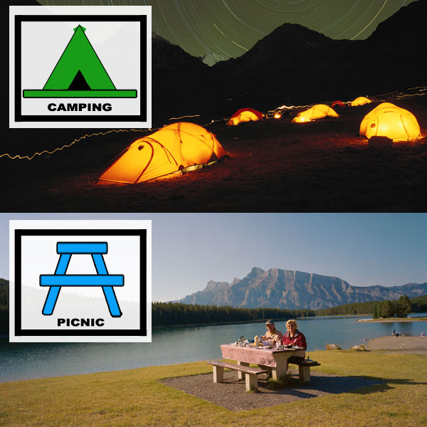
There is no universal system that requires particular map symbols to represent certain features in the real world. When looking at the system of symbols used in two different maps, however, it is often noticed that there are some similarities between symbols for common features including hospitals, post offices and railway lines. Since symbols are most effective when they can be logically associated with a specific feature in the real world, cartographers (people who create maps) always try to draw symbols which resemble the feature that they are representing. This is often why camping grounds are depicted by a simple triangular-shaped tent and picnic spots are conveyed by a picnic table and chairs.
See image 1
Image 1 – The familiar symbols for camping and picnic grounds
Not all symbols, however, have to look identical to what they are representing to be effective. If the same symbols are frequently used in the same way by different cartographers, they often become accepted as mapping conventions.
Through popular use, it has become a convention for certain colours to represent certain features. Aqueous (relating to water) landforms, including lakes and rivers, are almost always depicted on maps as blue in colour. Vegetation is often featured as green.
The use of size has also become a mapping convention. It is generally understood that the size of symbols, or the font size of labels, are linked with the importance or quantity of a feature on a map. Symbols used to denote settlements, for example, are often larger when representing places of a greater population.
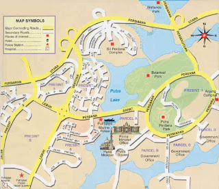
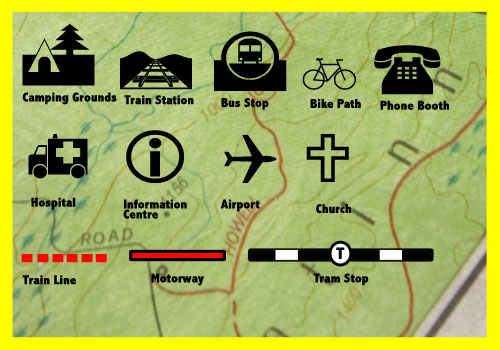
See image 2
Image 2 – Example map
What is a legend?
While there are a number of map symbols which are easily identifiable with a corresponding feature in the real world, this is not always the case. Without a legend, the numbers and lines found on contour maps, for example, would be meaningless to someone who lacked an understanding of topography (study of the shape and elevation of the landscape). This is why maps need legends.
A legend (also known as a key) is a table which explains the meanings of signs, symbols, colours and abbreviations used on a corresponding map or chart. A legend features each symbol shown on the map, with a short description of its meaning. The legend is usually located at the bottom of the map, or somewhere close to the margin of the page.
In an atlas, it is not uncommon for the legend to encompass an entire page. A legend in an atlas is generally applicable to every map featured. It includes a wide range of symbols for boundaries, roads and railways, buildings, mines and caves, agriculture and vegetation, rocks and minerals, languages, religions, and industries. The legend is displayed towards the front of the atlas, where it will be read before the maps.